


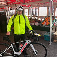
 The Celtic Cycling Circle
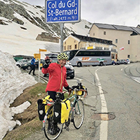 Cycling alongside the Grand Union Canal
 5 Essential Items to Take with You on Your First Cycling Tour
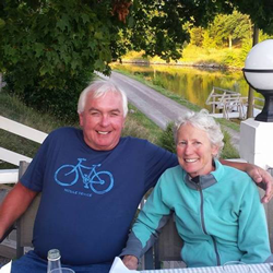 Favorite Cycling Destinations: Sardinia
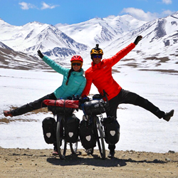 Pamir to Karakoram- cycling the highways on the roof of the world
 4 Wheels 2 Hearts 1 World - A Day in Our lives
 Koga E-Worldtraveller - e-bike review
 Ten tips for tandem cycle touring
 colmandsamstreks - Two Beginners in France
 Map of Norwegian tunnels
There are over 1000 road tunnels in Norway (we currently have 1266 marked on our map). As Norway improves it's road system there are more opening each year.
Some tunnels are often long (up to 24km), narrow and many are unlit. In one tunnel it was so dark even with reasonable lights and a head torch I got quite disorientated especially after being blinded by the lights of the on coming traffic and this coupled with the traffic noise which seems to be magnified 10 times this can make for a quite scary experience and not for the inexperienced rider!
Some of the tunnels are prohibited for cyclists by the Statens vegvesen the Norwegian roads authority due to various reasons, the amount of heavy traffic on the road, the length of the tunnel or the potential to fill with carbon monoxide from vehicle fumes due to poor ventilation. Please do not cycle through prohibited tunnels, the fines for doing so are very high. They have CCTV in the tunnels and if a cyclist is spotted in a tunnel the police will close a tunnel to traffic which will lead to delayed traffic and extra work for the emergency services.
A lot of the newer tunnels are an improvement to the old road and quite often the old road is the alternative route for cyclists which can be a nice respite from the traffic and usually much more scenic than the tunnel, although it might be a slightly longer route.
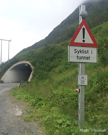
Some tunnels have 'Syklist i tunnel' warning lights outside to warn vehicles that there are cyclists in the tunnel. Look out for them and remember to push the button to activate them!
Please read the alternative route descriptions carefully as some alternative routes to the banned red tunnels are the old road that may go over the mountain and these may be blocked by snow in winter and may still be blocked by snow even in June!
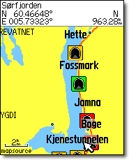
However not all the tunnels need caution to ride through. The map below shows the location of the Norwegian tunnels that we know of that are banned to cyclists. It also shows the tunnels that are open to cyclists with comments from the contributors that have cycled through them.
Each of the markers on the map below indicates a tunnel, if you click on the marker
an information window will pop up. Some of the tunnels have photos and if you click on the thumbnail image a larger photo will appear in a separate window.
Watch our HD Video which shows how to get the best out of the tunnel map including 'Street view' where you can virtually cycle through the tunnels.
If you would like to view the map to the full size of your screen please use this version here.
If you want to use the tunnel map whilst you are in Norway on tour you might find it useful to use this version here which will center the map on your smartphone or tablet to your current location. You will need to click OK to allow the map to use your current location.
Norwegian Tunnel Database
The Norwegian Tunnel map runs from a database which we have put together with the grateful help of the contributors mentioned below.
You can search the database for tunnels by road number on this search page.
You can search the database for tunnels by tunnel type on this search page.
The Tunnel database was last updated: 16.07.2026
Norwegian Tunnel POI file
The Norwegian Tunnel map database is also available as a POI (points of interest) file which can easily be loaded into a Garmin GPS as a Custom POI file. You will need to use the Garmin POI Loader software available here.
|
It uses the format [name]. [road no.], [tunnel length], [open or closed to cyclists], [lit or unlit], [Comment], [alt. route]. |
 There are several databases in the Tunnel map POI file that correspond to the traffic light colour scheme used to denote the type of tunnel.
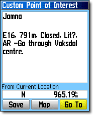 Each tunnel has a basic description of the tunnel.
 The Tunnel map POI file is available as a zipped file. Inside the zipped file you will find the POI files in 2 formats csv and gpx depending on what format your GPS uses. Should you wish to have a copy of the POI files for your own personal use to load onto a GPS please contact us |
We have successfully loaded these POI files onto a Garmin gps but as the files are in gpx and csv format they could be imported into other mapping software and they will probably work with other makes of gps. Due to the Norwegian characters used in some the tunnel names you may find that once imported you may loose some or part of the tunnel names but you should find that the descriptions should be intact. Please let us know if you have any success or problems with these files on other makes of gps, please contact -
If you have an Android phone or tablet with the mapping app 'Locus Pro' installed you can import the tunnel map POI files to view the tunnels on the map screen. We have created a separate set of icons to use with Locus Pro. Once you have downloaded the zip file you will need to use a file manager app such as 'ES File Explorer' to move the zip file to the 'icons' folder in the 'Locus' folder on your phone or tablet. You can find a step by step explanation on how to do this on our 'Installing the Tunnels POI files onto Locus Map' page. |
|

Contributors to our Norwegian Tunnels Database
Many thanks to the following:
| *Brian & Karen | Jerry Webb | Mark | Olaf Schultz | Alastair Jenkins |
| Grelus | Stan & Damae | Otto Mayr | SLF | Lasse Meholm |
| Durrin | Anthony | Cycling Dude | Cycle tour leader | Andrew McGill |
| Liz & Bernard | Norman Atkinson | SatNavSaysStraightOn | PAL | Gunnar |
| Suonio | Jutta | Torodd | Silje Kristiansen | Gerrit |
| Jim P | Markus | Igor Timoshin | Gu | Steve Selwood |
| Asger Yding Nielsen | meteor2017 | PeterM | Bernd | mooncycler |
| L-Green | Thomas.Hilde | Cecilie | Dick Ris | Ingbjørn |
| Jon Erik Berg-Hansen | John C | SivL | Noel J | Mike Watson |
| Dany | Knut K | Trygve | Frank | Paul Baumann |
| Tomberli | Cristina and Alex | Lars V | htverlid | Stavanger resident |
| Hans Mispelaere | Tristan Bogaard | F. Sanfilippo | JMT | Jan T |
| Eirik Vassenden | Tina | Pascal Picquot | Hans van der Veeke | Downhill |
| Laurence Boye | Trond Gravem | SprengeMobil | Martin Brice | Walter Hoogerbeets |
| Gudrun | Martin | Stefan | Vanda | Callum, Kate and Rachel |
| amichelic | Ron Gutteridge | Mike 2017 | Martin V | Arthur Lovell |
| Eoin Robson | nattetid | Kirsty | Liz | Ray Mundo |
| napau.andrei | Magne | Steve | Thomas | peellef |
| Dave Griffiths (Notts CTC, UK) | Christoffer | BV | Alexander Jansen | floma |
| Tromsorome | Grigory Mazurchik | Martin U | Timberworm | Stuart Lowe |
| Bernd B | Jens Glad Balchen | Junior | Stein | Esben Nedrebø |
| Etienne | Håvard | Cycle Tourer | Karen | Peter Elford |
| GeeWee | AndreasP | Steinar Hamre | Tor Havåg | KLF |
| F.C. Drost | Sondre M. Pettersen | napau.andrei | Antoine Dossot | Jens Glad Balchen |
| PiR | Beni | Island_Rides | chrisbuzz | F.C. Drost |
| Lolo | Erwin - 13.000k through Norway | MP | Knut Røneid | Baard Hermansen |
| Zwanet | Else | Emilie & Laura | Cyclist | Brynjar |
| Ingvill | Elena L. | Richard | Erlend Bjørge | Nina og Petter |
| Capitan | Rasmus | Svein | Steve | rhewlif |
| Steinar Hamre | napau.andrei | Øyvind | MatthewNorway | Guus Malenstein |
| M | Are Bruvold | Richard | Mats Mikkelsen | Steinar Hamre |
| Svein | Turid Williksen | Helge Nesse | Morten Fyhn Amundsen | Irv |
| Jw | wiily | Johnny Olsen | William Short | Johann Klubben |
| Joe Hobbs | MartinH | Laura | William | Anna & Robert |
| Rob Lee | André C | Jean Paul | Rien Boot | Kotti |
| Gianluca | Sevä | Willy jay | Jonis | Matthew Norway |
| Felltop | Leo Hendriks | MusaM8 | Malle | Abe |
Edgar |
Jens |
Hans-Jürgen Thoms | J.C. Apon | Nico |
| Nachos34 | Leo Hendriks | Bast | Roger Good | Phillip Kaspersen |
| Simon R | Joshua Forester | Harry | H Hill | hal |
| Synne Rystad | Ken Bayne | Sabine | Robert Bergersen Skaar | John Street |
| Brynjar Bakken Aarskog | Clément Sartoni | Marc F. | Osh | Felix Miller |
| Trond Solem | Erwin - 13000k through Norway | Sebastian | Elzapatero | SdB |
| Haakon L | Andreas | Bikepacker | Just a cyclist | 2wheelsgood |
| Kacper | Mags | Joël | Ronny Holm | Dozzy aussie |
| Mar | Birgit Løppenthien | Tervelo Tours | Nordkapptunnelen Is OK | blind_ranger |
| 7 weeks through Scandinavia | Torstein S | BiffeurCC | PB | Martin Krist |
| bizzmane89 | MaxT63 | Anders | Gonger | alex |
| Gonger | Ragnhild | Radler | E. González | ITU |
| Simnono | Ian To | PDP91 | Julia | Stefan Plieth |
| Ronnie | Dora | X | Bjørn | S Wilton |
* Special mention must be made to Brian and Karen of WheelBuddies for allowing us to use the tunnel information of the current banned tunnels from their web site and for providing the data in a very helpful spreadsheet format. The tunnel map would not be the same without their considerable input and encouragement.
Please note that this map, database and associated files are for guidance only to help someone in planning a tour in Norway, we hope that the information supplied by the contributors is given in good faith, however we as owners of this site cannot be held responsible for any inaccuracies in the information contained on the map, database and associated files.
Contributing to the Tunnel Map
If you have additional information about any tunnels then please complete one of the following forms :
For additional comments
on tunnels that are
already on the map.
For reporting new
tunnels that are not
on the map.